Dear Guest,
Porto Pino is an excellent starting point to visit Sulcis Iglesiente and we have here the pleasure of proposing you some itineraries that will make you discover this amazing territory. Besides the typical destinations mainly located along the coast, the itineraries also include several areas in the hinterland, perhaps not as well known as the former ones but not for this less beautiful and suggestive.
We have adopted two description systems, which differ from each other for the method and the deepening of the information, to present the itineraries.
If you want a practical and fast guide of the territory, please click on wikitinera.it where we have published some itineraries.
If you want more information about the places you will visit we suggest you to consult the following pages. In this case, each itinerary refers to a representative panoramic viewpoint of the area and it is equipped with several Points of Interest that we strongly suggest you to visit if you want to know the environment, the history and the culture of this splendid region. Each itinerary is also equipped with a map with the coordinates of the suggested legs which you can put into your GPS.
Enjoy yuor trip
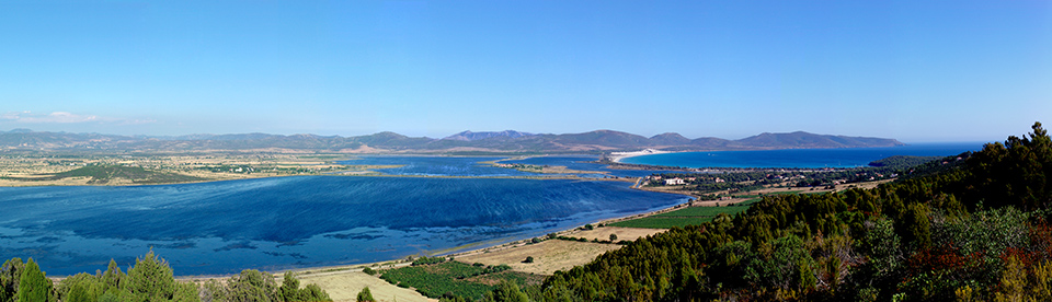
Panorama da Monte Sarri
Travel time: 2-4 hours
Distance of the panoramic point from Villa Ebner Residence: 0,5 km
Panoramic point coordinates: 38.978532° - 8.590537°
Top places : Dunes and beach of Porto Pino, Pineta Candiani.
Between our observation point and the gibbous mountain ridge of Punta di Cala Piombo, in the background the coastline follows a deep inlet bordered by a long beach separating the open sea from the saltwater ponds linked by artificial canals (the Maestrale, Corvo, Is Brebeis, and Foxi ponds). To the left, beyond the ponds, the interior stretches into vast grassy flatlands extending to the mountains above the town of Sant’Anna Arresi.
Read more: Monte Sarri (Porto Pino)
 Panorama from Capo Spartivento
Travel time: 1 day
Distance of the panoramic point from the Villa Ebner Residence: 45 km
Panoramic point coordinates: 38.877893° - 8.845158°
Top places: Capo Malfatano, Spiaggia di Tuerredda, Spiaggia di Chia, Chiesa e Torre di Sant'Isidoro.
West of the plain on which rises the Capo Spartivento lighthouse is one of the most beautiful landscapes on Sardinia’s southern coast. For miles you can see a sequence of rocky promontories, craggy cliffs and more or less deep inlets rimmed with small white beaches. Above the reach of the waves the rock is covered with low-lying vegetation, a garigue rich in juniper, lentiscus, phillyrea, in some areas dominated by dense growths of shrubby spurge that in springtime form extensive swathes of color running from yellowish green to wine-lees red. Far from the coast the rock outcrops again among the shrubs, forming rugged surfaces accentuating the wild nature of the terrain.
Read more: Capo Spartivento (Chia)
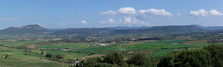
Panorama from Pani Loriga
Travel time: half day
Distance of the panoramic point from Villa Ebner Residence: 22 km
Panoramic point coordinates: 39.088930° - 8.689409°
Top places: Area Archeologica di Pani Loriga, Necropoli di Montessu, Menhir Luxia Arrabiosa, Santadi.
The panorama stretches across the plain on which lies the village of Villaperuccio and the range of hills delimiting its northern edge. The history of this landscape dates back to the Oligocene-Miocene epoch, between 14 and 32 million years ago, a period in which were formed the rocks that now constitute the tabletop hills, locally known as Is Praneddas and undoubtedly the zone’s most characteristic feature.
Read more: Pani Loriga (Santadi)
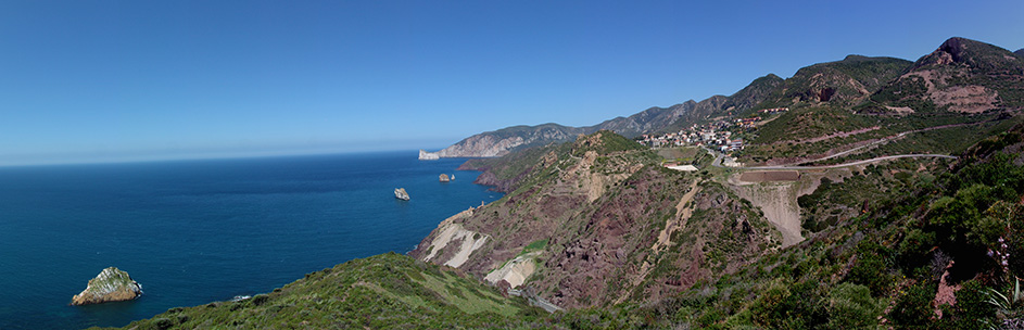 Panorama from Nebida
Travel time: 1 day
Distance of the panoramic point from Villa Ebner Residence: 50 km
Pamoramic point coordinates: 39.305733° - 8.436987°
Top places: Porto Flavia, Laveria La Marmora, Miniera di San Giovanni, Iglesias.
North of the Fontanamare beach the coastline cuts into the mountainous Iglesias massif, defining its western geographical limit. Here the passage from land to sea looks rather brusque, a jagged edge due to the steepness of the slopes that seem to extend into jutting rocky islets scattered all along the coast. Geology’s influence on the area’s landscape is obvious: depending on rock type, the rises not only take on different shapes but also coloration and often have a type of vegetation that differentiates them from the surrounding areas.
Read more: Nebida (Iglesias)
")
")