")
")
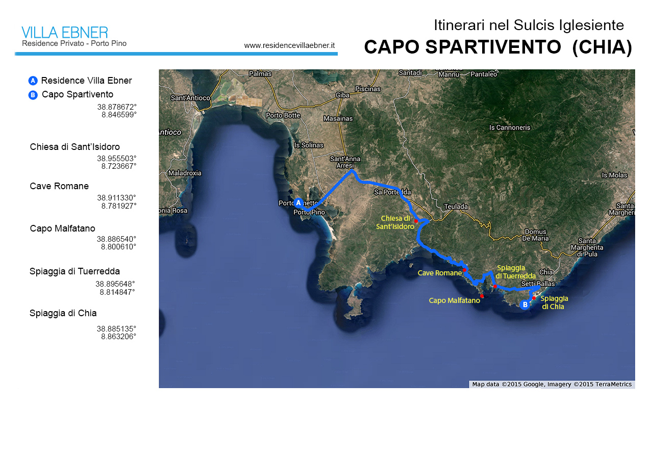
Capo Spartivento (Chia)
 Panorama from Capo Spartivento
Travel time: 1 day
Distance of the panoramic point from the Villa Ebner Residence: 45 km
Panoramic point coordinates: 38.877893° - 8.845158°
Top places: Capo Malfatano, Spiaggia di Tuerredda, Spiaggia di Chia, Chiesa e Torre di Sant'Isidoro.
West of the plain on which rises the Capo Spartivento lighthouse is one of the most beautiful landscapes on Sardinia’s southern coast. For miles you can see a sequence of rocky promontories, craggy cliffs and more or less deep inlets rimmed with small white beaches. Above the reach of the waves the rock is covered with low-lying vegetation, a garigue rich in juniper, lentiscus, phillyrea, in some areas dominated by dense growths of shrubby spurge that in springtime form extensive swathes of color running from yellowish green to wine-lees red. Far from the coast the rock outcrops again among the shrubs, forming rugged surfaces accentuating the wild nature of the terrain.
Such a jagged coastline is the product of the sea’s incursions into valleys previously cut by rivers, whose former slopes have been denuded by marine erosion (rias coast). Also accentuating the land’s morphology is the great variety of rocks forming the coast itself: the entire zone from Monte Sa Guardia Manna down to part of Capo Malfatano is pink granite, whose high degree of fracturing confers that jagged look typical of the cliffs of the Padiglioni and Ferraglione Islands. Going west, beneath a layer of golden yellow sandstone along the waterline outcrop schists and other metamorphic rocks colored grayish-green to violet, which together create softer contours than those of the granites because they are less resistant to erosion by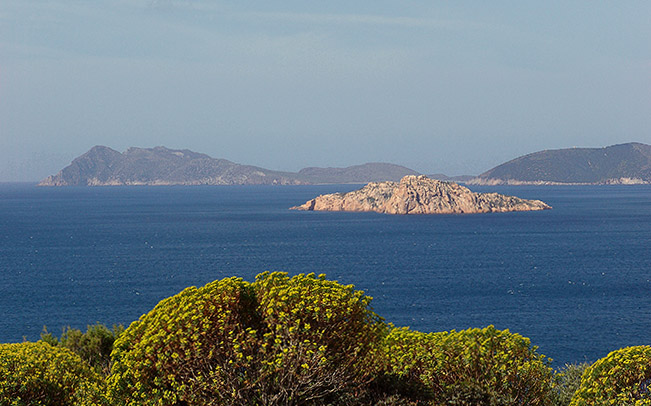 sea and wind. Finally, after a brief reappearance of granites at Porto Teulada and Isola Rossa, we find outcroppings of the white limestones forming the impressive Capo Teulada cliff. A collection of rocks to whose variety is added the value of rarity: many of them date from the Paleozoic, are the oldest rocks in Italy and, while fairly frequent in the Sulcis-Iglesias area, seem here to be associated with portions of rock that are even more ancient, perhaps 670 million years old and among the oldest in all of Europe. But it is not the age of the rocks that gives such a primitive look to the landscape in this area: over such a vast expanse, the absence of visible signs of human inhabitance inevitably evokes the idea of a primordial landscape or at the most one in which, for once, humans have played a minor role. Yet following the coastal road one discovers that, in reality, people have assiduously frequented these places, and with little scenic sensitivity, but certainly the traces of human passage do not render justice to the intensity of the historic events that have occurred here. The presence of numerous nuraghi, many badly conserved, testify to the fact that even prior to 1000 B.C. the zone was undoubtedly populated, especially in the immediate hinterland. In particular, it appears possible to identify traces of lines of defense along the main access routes to the inner valleys where in all likelihood most of the settlements were found.
 And yet the Phoenicians were the first real frequenters of the coast, initially with seasonal visits to establish trade with the islanders and later in a more stable fashion until, mainly with the arrival of the Carthaginians, even quite large settlements were built. Thus was born Bithia, on the Chia shore, recognized as the most important Phoenician-Punic city in Sardinia, and minor towns arose along the entire coast nearly to Capo Teulada, the ancient Chersonesus (a name also given to other Mediterranean peninsulas), where a fortress was built near Porto Scudo to protect the landing-place at Cala Zafferano. Along with these ruins, of which little tangibly remains, is a structure that may be the most concrete imprint of the Punic presence along the coast. In the bay delimited to the west by Capo Malfatano, just two meters below the sea ar
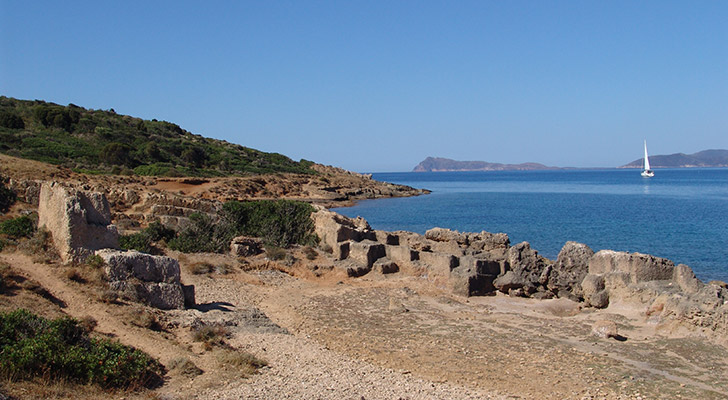 e two walls of a total of some 200 meters long, separated by a corridor of similar length. According to certain scholars this could be the port of Melquart, the Punic Hercules, perhaps documented as the Portus Herculis given on Ptolemy’s maps.. While the origin of these walls is still a mystery, it is likely that some features of the current landscape can be traced to their construction: the sandstone quarries still plainly visible along the coast around Capo Malfatano, from which were extracted a huge number of blocks, perhaps used to build the port. Supporting the hypothesis of an important Punic settlement at Capo Malfatano is the presence on Tueredda Island of a tofet, a sort of sanctuary-necropolis typical of Carthaginian culture and similar to the one found on Su Cardulinu Island opposite the city of Bithia. Even in Roman times the coast must have been densely populated, but traces dating from that epoch are limited to scattered finds. In any case, dating from the Roman period is the presence at
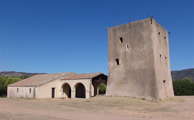
Porto Scudo of a village called Tegula, in a strategic position between Nora and the city of Sulci. In the Middle Ages the village was abandoned and re-founded only in the XIV century as Teulat, located near what is now the Church of S. Isidoro. In the XVII century, probably because of frequent Saracen raids, its inhabitants moved further inland, founding what is now Teulada. Much more evident are the relics of Spanish dominion, a period that saw construction of the numerous watchtowers defending against Berber incursions at strategic points along the coast from Chia to Capo Malfatano, Piscinnì to Porto Budello and Porto Scudo. Here, more than in other parts of the Sulcis coast where they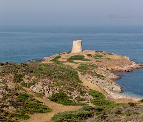 are found, the towers strongly characterize the landscape and testify to an aspect anything but secondary in the island’s history: wars. In addition to the aforementioned port of Melquart, probably an important base for the Carthaginian fleet in its wars with Rome, through the centuries the sea in front of this coast was the site of many naval battles, the most recent of which was in November 1940, between the Royal Italian and Royal British Navies in an event known to history as the Battle of Cape Teulada. Unfortunately even today, in peacetime, the zone continues to be heavily involved in military activity. The whole area between Porto Teulada and Porto Pino (covering a total of 18,000 acres) has been transformed into a war-simulation zone for NATO forces forces with large-scale use of munitions of every type. An easement that in addition to impeding use of the land and a good 750 sq km of sea, greatly harms the environment, compromising use of the area even should the base be removed in future.
Copyright Frederick Bradley - Riproduzione vietata