")
")
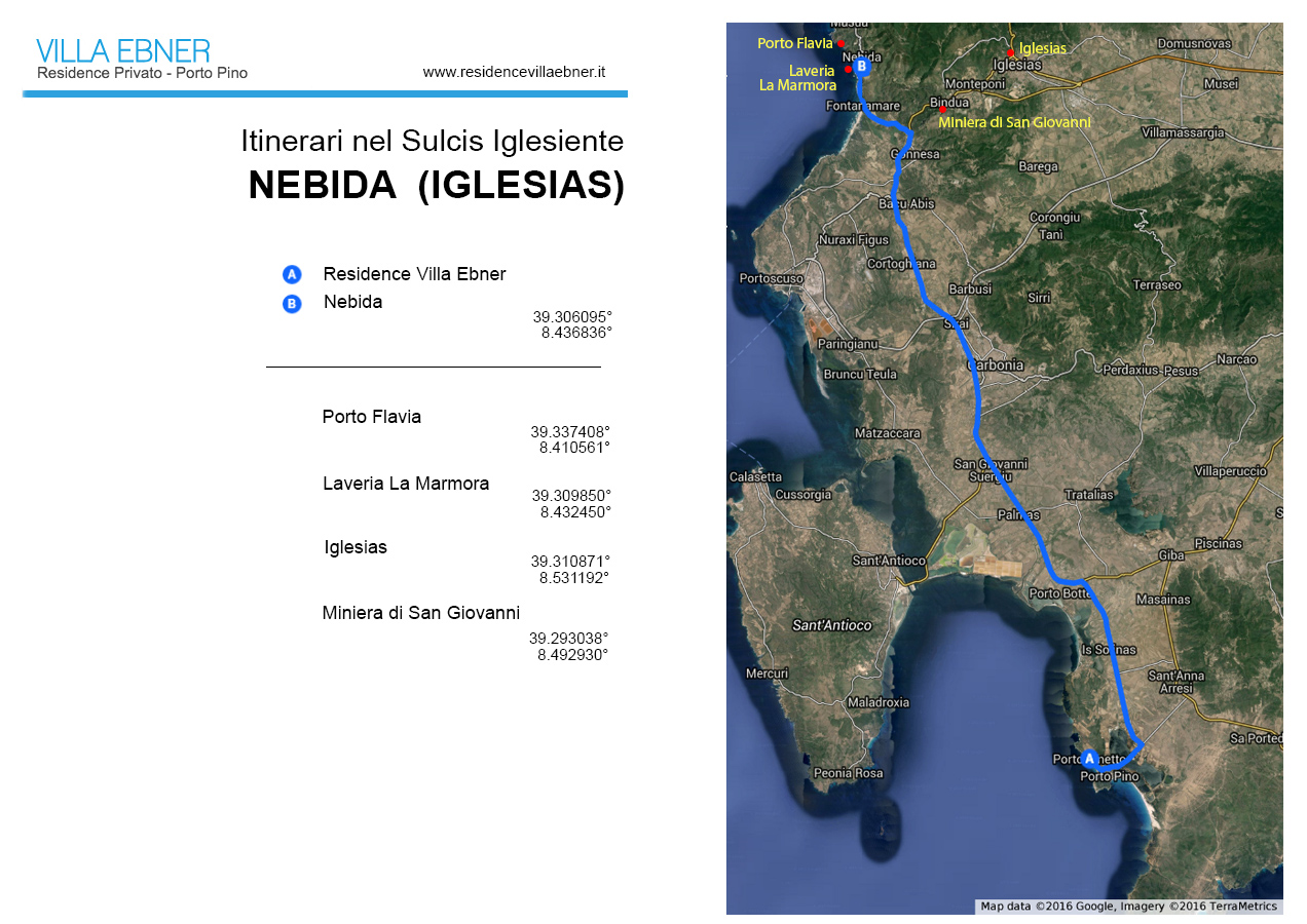
Nebida (Iglesias)
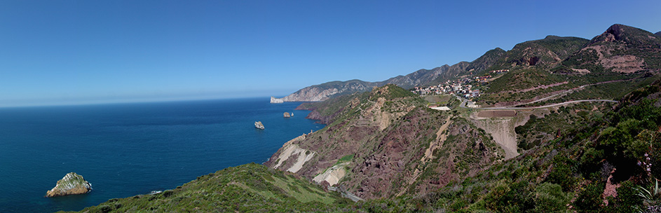 Panorama from Nebida
Travel time: 1 day
Distance of the panoramic point from Villa Ebner Residence: 50 km
Pamoramic point coordinates: 39.305733° - 8.436987°
Top places: Porto Flavia, Laveria La Marmora, Miniera di San Giovanni, Iglesias.
North of the Fontanamare beach the coastline cuts into the mountainous Iglesias massif, defining its western geographical limit. Here the passage from land to sea looks rather brusque, a jagged edge due to the steepness of the slopes that seem to extend into jutting rocky islets scattered all along the coast. Geology’s influence on the area’s landscape is obvious: depending on rock type, the rises not only take on different shapes but also coloration and often have a type of vegetation that differentiates them from the surrounding areas.
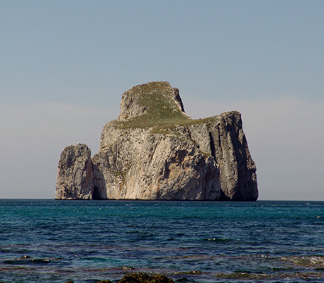 On the slopes near the sea outcrop mostly green schists and metamorphic conglomerates in an unmistakable liver red color, on which grows thick vegetation featuring the frequent presence of cushions of spurge. On the right side of the panorama instead prevail pale limestones covered in a sparse shrubby maquis composed primarily of clumps of lentiscus and phillyrea; these same limestones constitute the immense cliff of Shina ‘e Monte Nai in the background and continue in the Pan di Zucchero (Sugarloaf) , formerly known by the Sardinian term of Concali su Terrainu: an outshoot of rocky coast transformed into an island through the demolition worked by the sea and other erosion processes. Finally, in the midst of the vista, from the red conglomerates rise uneven masses of carbonate rocks different from the aforementioned limestones, the same that form the minor islets found along the coast – monolithic rocks almost devoid of vegetation.
This lithological variety is the sign of a complex geological structure hosting some of the oldest rocks not only in Italy but also on the entire European continent, and so significant as to arouse the interest of scholars around the world. In detail, the conformation of the rocks marks the passage between the Cambrian and Ordovician periods, occurring 500 million years ago and an event that coincided with the great upheavals that determined the geological destinies of the part of Sardinia then existent. And while these geological peculiarities mainly intrigue a select few in the scientific world, of equal interest but with quite another significance are the zone’s mineral characteristics. Here, in the area sur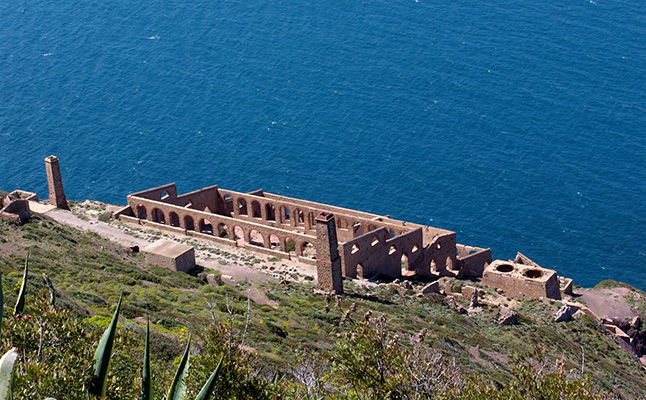 rounding the towns of Nebida and Masua are some of Sardinia’s most important deposits of galena and blende, minerals useful in lead and zinc extraction and often found together with an exploitable amount of silver. And it was mining, begun in the mid-1800s and abandoned over a century later, that led to creation of the first human settlements in the zone, whose still visible traces comprise fundamental features of the scenery. The large mine-openings on the limestone slopes are surrounded by debris dumps, partly hidden by the re-growth of natural vegetation. More extensive debris dumps can be seen on the slopes overlooking the coast: here the waste material came not from the mines but from the first stages of how the raw mineral was worked in the past. These relics, taken for granted in a mining area, are joined by others that are more significant and by now a legacy of industrial archeology and thus part of local culture. They are the basic infrastructures of mining work itself, and first among them the Laveria Lamarmora, the washery where the raw mineral was enriched. Imposing yet elegant, thanks to its architectural style and construction features this stone-arched edifice built in 1897 (whose modern counterpart would be an anonymous industrial plant) blends in perfectly with the landscape and even gives it a strong cultural connotation. Inside this authentic monument are other interesting elements such as outbuildings and wagon roads for hauling the raw mineral from the mine to the washery, now converted to a tourist belvedere.
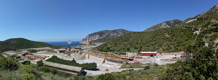 The town of Nebida itself, like Masua (not visible in the panorama) owed its origins to mining development. Both towns still hold vibrant traces of the past, both recent and remote. Among them are the huge deposits of mud generated by the mineral-processing methods used until the mid-XX century that totally occupy the Masua valley and are, among other things, a potential danger not only for the hydro-geological make-up of the zone but also for the concentration of heavy metals in the aquifers. Here and there fine homes, while long abandoned, are still lovely to look at, testifying to a golden age that is now definitively past.
 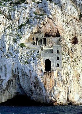 But perhaps the most outstanding relics are found – as could be legitimately expected, where mining is concerned - within the earth. One example is the existence among the mines uphill from Nebida and the Laveria Larmarmora of a pit connected to a deep horizontal tunnel used to transport the ore. Even the limestone promontory of Schina ‘e Monte Nai contains a structure that played a key role in the whole area’s mining development: to lessen transport costs, in 1925 engineer Cesare Vecelli commissioned a structure that enormously facilitated loading the ore on mercantile ships. The whole loading system, named Porto Flavia after the engineer’s eldest daughter, consisted of nine huge silos dug inside the mountain for total capacity of 10,000 tons. Through a series of tunnels the mineral was first stored in the silos and then taken to the embarkation site located on the sheer seaside cliff at a height of about fifteen meters. From here the mineral was loaded onto the ships below by means of a metal pontoon that guaranteed loading speed of 4,000 tons an hour. This bold feat of engineering, still intact in its basic structure, has been equipped for guided tours and is one of the main tourist attractions at Sardinia’s Geological Park. An asset added to the extraordinary beauty of the landscape’s prime components: the monolithic rocks and Pan di Zucchero just offshore, the Schina ‘e Monte Nai cliff and, further north, the Canal Grande along the coast towards Cala Domestica, all declared national monuments.
Copyright Frederick Bradley.