")
")
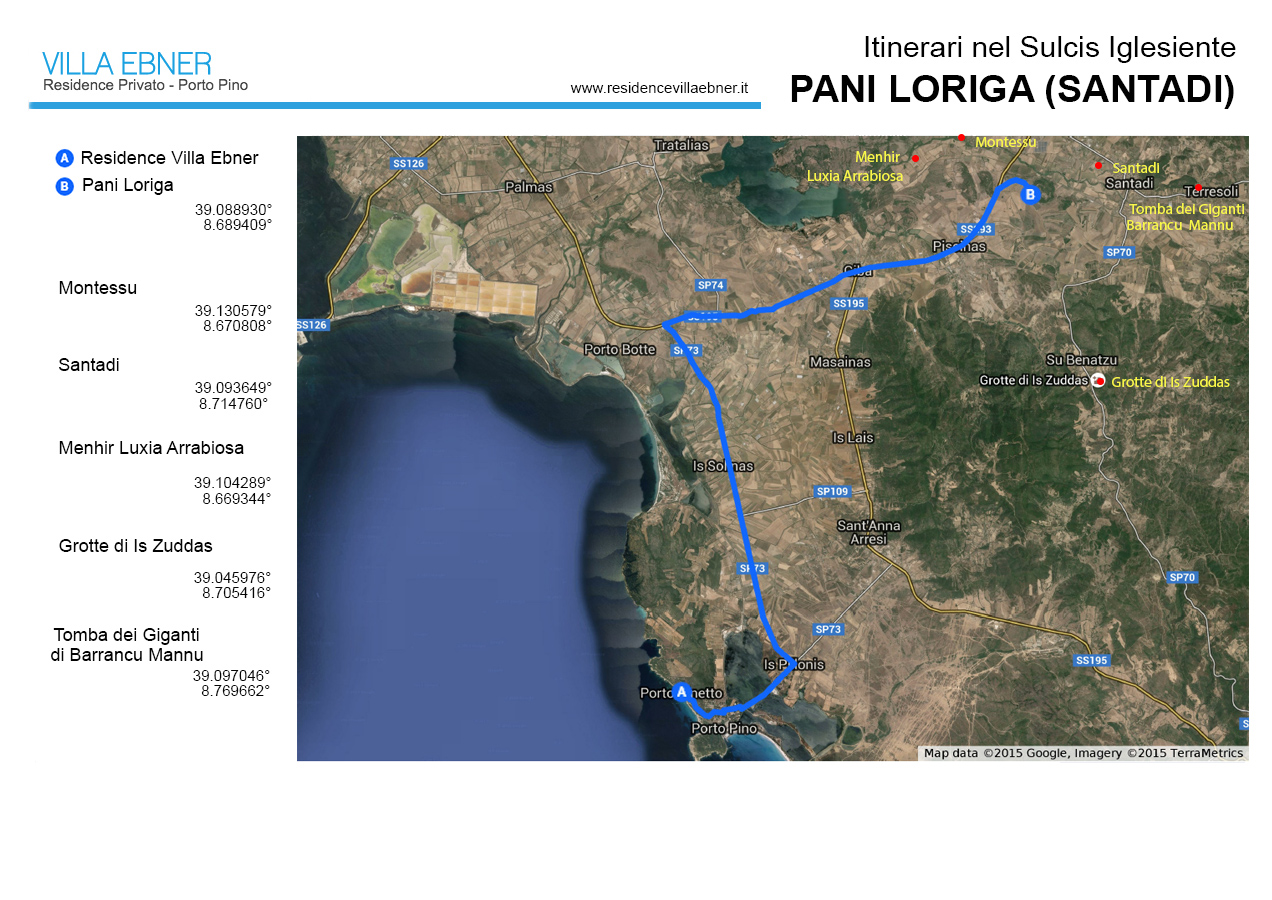
Pani Loriga (Santadi)
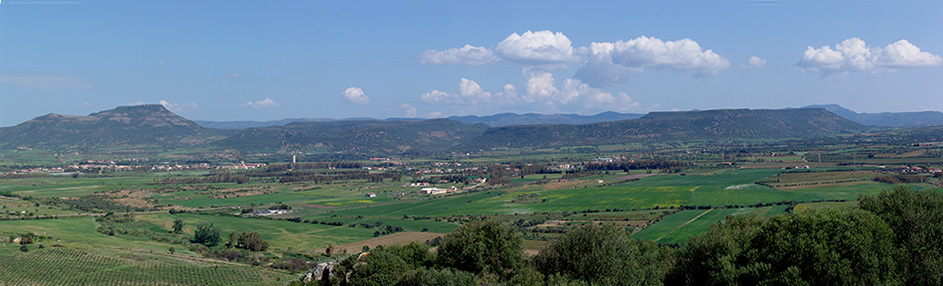
Panorama from Pani Loriga
Travel time: half day
Distance of the panoramic point from Villa Ebner Residence: 22 km
Panoramic point coordinates: 39.088930° - 8.689409°
Top places: Area Archeologica di Pani Loriga, Necropoli di Montessu, Menhir Luxia Arrabiosa, Santadi.
The panorama stretches across the plain on which lies the village of Villaperuccio and the range of hills delimiting its northern edge. The history of this landscape dates back to the Oligocene-Miocene epoch, between 14 and 32 million years ago, a period in which were formed the rocks that now constitute the tabletop hills, locally known as Is Praneddas and undoubtedly the zone’s most characteristic feature.
In that epoch most of what is now the Sulcis consisted of a depression capturing the fluvial deposits coming from the Iglesias-area hills and the massif that begins at Punta Is Caravius. Above these sediments, explosive magmatic eruptions deposited a thick layer of lava and pyroclastic rocks which, instead of forming classic volcanic cones, were deposited first as shapeless boulders and then into an extensive horizontal layer of ignimbrite, a volcanic rock formed by burning clouds exiting from erupting mouths. This sheet of ignimbrite now constitutes the surface of the tabletop hills, Originally, the settling of the volcanic sheet uniformly covered the depression on which i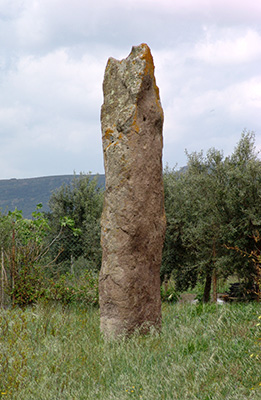 t deposited and must have looked like a single horizontal platform, but about six million years ago, in the Pliocene, it broke into many parts that collapsed at different speeds, creating the difference in altitude between the hills we see today. Finally, erosion processes began (and continue), leading to a perceptible reduction of the volcanic deposits from their original breadth. In addition to shaping the landscape so peculiarly, the special geological origin of the area played a key role in the human settlements that succeeded one another through the millenniums. Both the plain and the hills reveal numerous traces of human inhabitation since the Later Neolithic, to the point that the entire zone is one of Sardinia’s most important sites of pre-nuraghic archeology. Here Neolithic people found three essential elements for widespread, stable occupation of the territory: very fertile soil, deriving from the crumbling of volcanic rock, water (guaranteed by runoff from nearby mountains) and the presence of sites which, for type of rock and morphology, were suited to creating burial grounds and places devoted to religious rites.
The archeological importance of the Villaperuccio zone lies in the fact that different areas have been identified that must have corresponded, respectively, to a village, a necropolis, and a place of worship for the inhabiting population. The main settlement was on the plain at a site (S’Arriorgiu) near a zone with features favorable to farming. Also on the plain, in the Terrazzu locality not far from the S’Arriorgiu village, relics of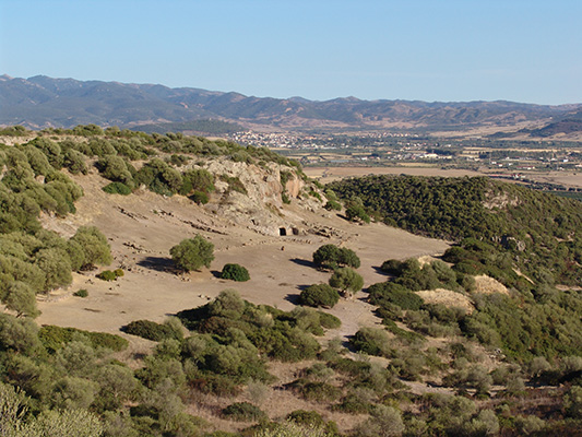 a religious site have been found in the form of several menhir, one about 5 meters high and called Luxia Arrabiosa, the name of a giantess often featured in Sardinian folktales. In addition to this site, doubtless the area’s most significant, menhir have been found in other localities, emphasizing how religious practices tied to megaliths were quite common throughout the zone.
But the most important trace left by pre-nuraghic peoples is indubitably the subterranean necropolis of Montessu, located on the upper southern slope of the homonymous mountain, one of the many praneddas in the zone. The necropolis contains approximately forty domus de janas, tombs carved right from the ignimbrite constituting the summit of the mountains. This site was probably chosen for the presence of volcanic rock, compact and fairly friable and thus easy to cut, but the natural scenery of Montessu must also hav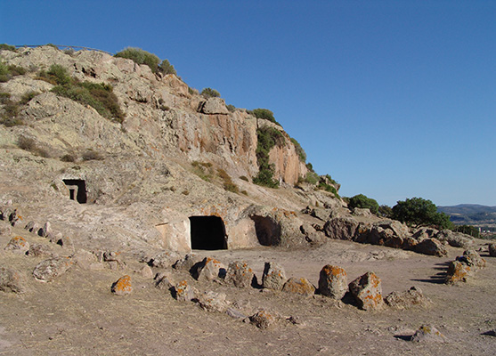 e had its weight: even a rational third-millennium visitor cannot help but feel a magical aura mixed with a profound sense of quietude enveloping the rocky amphitheater in which the necropolis lies.
The zone must also have been very attractive to the populations appearing later, both in the Aeneolithic and in the Bronze Age, when nuraghic civilization took hold. The position of the settlements, almost all of them localized on the hill slopes, indicates the importance of having a vista permitting surveillance of the territory. The number and arrangement of the nuraghi, dozens of them, suggests the creation of authentic lines of defense built at different heights to control access to the valleys and watercourses.
And it was exactly to guard the territory that settlements were also built on the Pani Loriga hill, whose summit is our observation point. Populated in pre-nuraghic and nuraghic times, it testifies respectively to the presence of domus de janas and a nuraghic village and in the Phoenician-Punic epoch Pani Loriga was the site of a fortress (VII century B.C.) that, together with the ones on Monte Sirai and Sa Corona Arrubia, played a key role in controlling movements in the Sulcis-Inglesias territory. The fortress was protec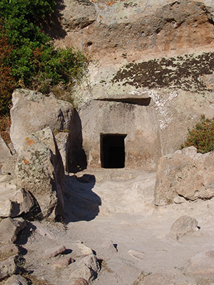 ted by three encircling walls, inside which one can still see the ruins of both an acropolis and a necropolis, composed of about 150 tombs, and the sacrificial area, the tofet.
With Rome’s victory over Carthage and later dominion over Sardinia, interest in the area was once again in farming. Evidently less concerned with military control over a mostly subjugated territory, the Romans primarily devoted themselves to developing farmland on the plain, probably constituting a tiny portion of the immense Roman granary that Sardinia must once have been. Traces of Roman inhabitation, including a necropolis, can be found scattered over the plain surrounding Villaperuccio, but relics of the actual settlements were long since destroyed, probably in moving earth to create the farmlands that have been worked through the centuries to the present day.
The scenery is a fine testimonial to the plain’s agrarian vocation. In effect, aside from limited clay extraction, the local economy depends on cereal and vegetable crops. Other revenue comes from tours of the Is Zuddas cavern in the Paleozoic limestone on the Santadi hills, and the opening of the Montessu necropolis to the public is another step in this direction, although the great tourism potential linked to the history and archeological wealth of the zone has still to be exploited.
Copyright Frederick Bradley - Riproduzione vietata