")
")
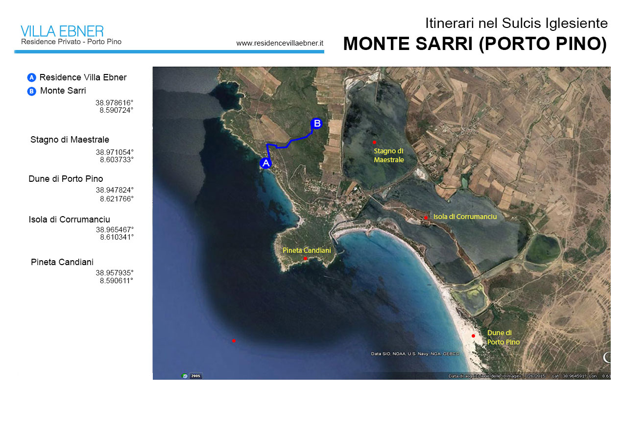
Monte Sarri (Porto Pino)
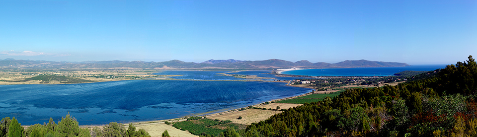
Panorama da Monte Sarri
Travel time: 2-4 hours
Distance of the panoramic point from Villa Ebner Residence: 0,5 km
Panoramic point coordinates: 38.978532° - 8.590537°
Top places : Dunes and beach of Porto Pino, Pineta Candiani.
Between our observation point and the gibbous mountain ridge of Punta di Cala Piombo, in the background the coastline follows a deep inlet bordered by a long beach separating the open sea from the saltwater ponds linked by artificial canals (the Maestrale, Corvo, Is Brebeis, and Foxi ponds). To the left, beyond the ponds, the interior stretches into vast grassy flatlands extending to the mountains above the town of Sant’Anna Arresi.
Both the coast and the Porto Pino hinterland lie on a tectonic trench delimited by faults running along the rim of the surrounding rises. As we see it today, the terrain is the result of the trench having been filled by the alluvial debris borne by watercourses over the millenniums. In fact, the longshore bar on which the Porto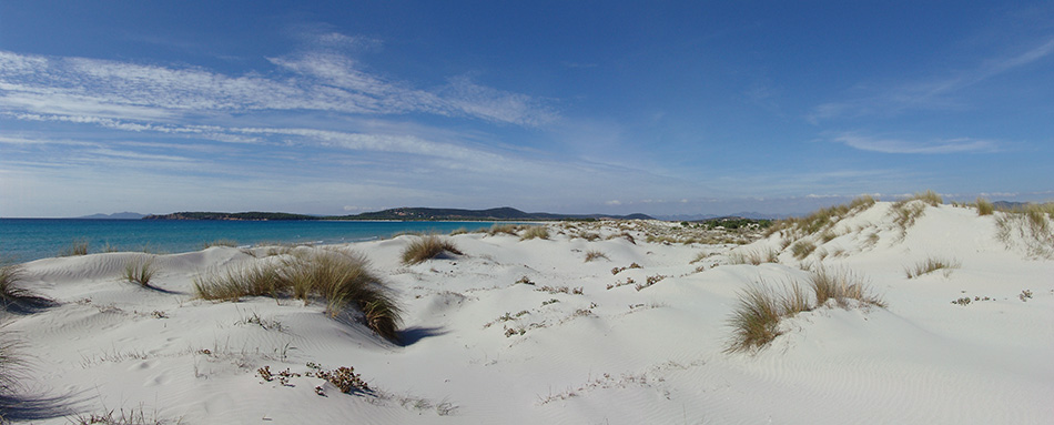 Pino beach lies is a tombolo that sea currents formed, utilizing the detritus coming from inland; on this detritus the incessant action of the wind accumulated and shaped dunes of extremely fine quartzose sand which, due to the predominance of the mistral, blowing from NW, are bigger on the southern part of the beaching, reaching a height of about thirty meters.
The formation of this longshore bar, occurring about 6,000 years ago, was only the last act in the creation of the entire pond complex. It followed the formation of a similar but much older shape of the current beach, whose vestiges can still be seen in the spit of land running parallel to the bar, tracing its shape and position. This is the so-called island of Corrumanciu, a long strip of land separating the seawards Corvo pond from the Is Brebeis, further inland. Before occupying its current position the coastline was probably where the islands now stands and the Corvo pond actually open sea.
This area, today so seemingly uninhabited, was once heavily frequented by humans and has a history-rich past. The earliest testimonies to a human presence in the Porto Pino zone date from the Late Neolith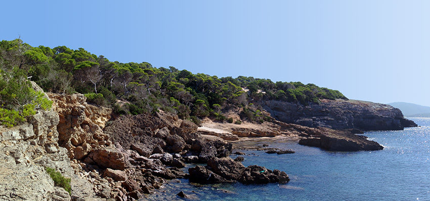 ic, and in the nuraghic epoch there were many settlements scattered through the area. Unfortunately, most of the ruins have disappeared, but around the ponds you can still find traces of numerous nuraghi and nuraghic villages.
Between the IX and VIII centuries B.C. the zone was frequented by the Phoenicians and, in the VI century, colonized by the Carthaginians. It was from that time that humans began to leave an important, and in many ways irreversible, imprint on the landscape. During Punic colonization and later Roman domination, timber felling and the creation of pastures and arable fields accentuated the deforesting already practiced in the nuraghic period. The zone became an important access route to the interior and at Porto Pino was built a port whose traces are still quite visible along the rocky coast at the entrance to the current channel port. The need for building materials led to opening stone quarries similar to the ones along the Capo Malfatano coast. In particular, from Punta Tonnara and all along the coast west of Monte Sarri were opened numerous quarries that now lie partly undersea, the obtruding parts serving as impromptu perches for sunbathers. Historic documents and numerous archeological finds lead us to assume that, in the Punic period, between the Maestrale pond and on the plain east of Monte Sarri, towards Porto Botte, there stood an extensive settlement, perhaps Ptolemy’s Sulcitanus Portus, now completely lost. Corroborating this not entirely fantastic hypothesis, folktales speak of a paved road at the bottom of the Maestrale pond.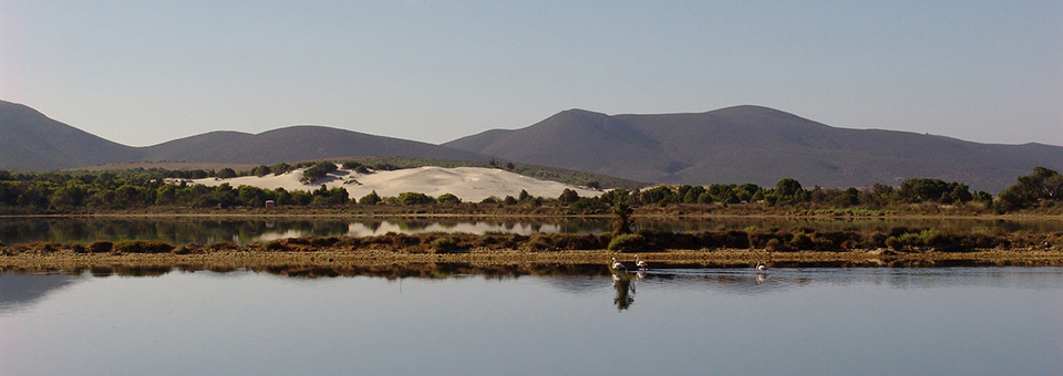
From medieval times to the end of the nineteenth century the area aroused the interest of the various dominators succeeding one another through time, attracted by the excellent revenues afforded by exploiting the ponds as salt pans or fisheries. According to historic documents it appears that during these centuries the true productive vocation of the zone lay in using the ponds as salt sources. And in effect, many place-names still refer to this work: even the name of our observation point, Monte Sarri, near the Maestrale pond, derives from sari, meaning salt.
The seawater ponds went back to being large-scale fish-raising grounds in the early XX century when English entrepreneur Menj Egerton Piercy took over the Porto Pino fishery, introducing an innovative way of using the land that also benefited the local population. Piercy also built the first important roads, including the current one connecting the coast with S. Anna Arresi, and replanted great quantities of Aleppo pines, a tree typical of the zone that gave its name to Porto Pino. Even after Piercy’s time the saltwater ponds were used to breed fish, but in the 1960s this business came nearly to a halt because they were inserted into the industrial system of the S. Antioco saltworks, making the Porto Pino ponds sites for pre-concentration of the saltwater, afterwards sent to other basins for total evaporation. Lately, local policies have given new impetus to professional fish-raising.
The 1960s also brought tourism to Porto Pino. After a long period of limited frequentation, with the beginning of the new millennium tourism development has definitely taken the road typical of seashore resorts, where the beach and recreational activities are the foc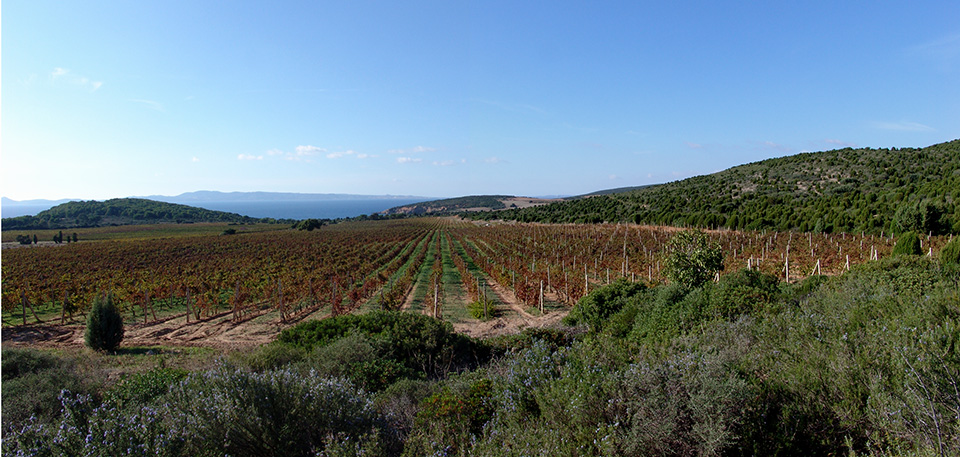 us of sector operators. In reality this is a decision that not only jeopardizes the environment (thus risking failure in the medium-term) but also limits the potential of a territory still possessing the ideal characteristics for developing sustainable tourism covering the area as a whole, ponds and inland zone included. It should be mentioned, apropos, that the ponds have great interest from the naturalistic standpoint, hosting exceptional bird species such as the black-winged stilt, purple gallinule, black stork and above all the flamingo, whose population makes the Porto Pino ponds one of Italy’s most important wetlands. Recently, even the area’s grape-growing industry, distinctive for its fine wines, has increased the amount of land devoted to vineyards, as can be seen in the coastal landscape.
Copyright Frederick Bradley